Search Results

- IDNO:
- 026339
- Title:
- New River Near Radford, Va.
- Date:
- 1932
- Description:
- 'Looking east northeast along second big bend of river below Radford. Virginian Railway reaches river from Roanoke and east near upper right-hand corner and follows down east bank of river; Norfolk and Western has crossed to west side and is about under plane.'

- IDNO:
- 026340
- Title:
- New River Near Churchwood, Va.
- Date:
- 1932
- Description:
- 'Looking south at mile 127; Norfolk and Western at right; Virginian Railway at left; Churchwood, Virginia, a coal mining town, near right foreground.'

- IDNO:
- 026347
- Title:
- New River Near Pearisburg, Virginia
- Date:
- 1932
- Description:
- 'Looking northeast at mile 105.6. Pearisburg, Virginia, below and to right of picture; Norfolk and Western to right; Virginian Railway to left of river as in pictures 45 to 55; base of a spur of Peters Mountain in background.'

- IDNO:
- 026349
- Title:
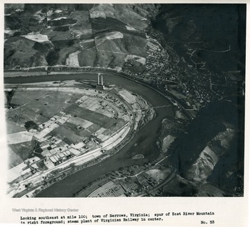
- New River Near Narrows, Virginia
- Date:
- 1932
- Description:
- 'Looking southeast at mile 100; town of Narrows, Virginia; spur of East River Mountain in right foreground; steam plant of Virginia Railway in center.'

- IDNO:
- 026352
- Title:
- New River Near Glenlyn, Virginia
- Date:
- 1932
- Description:
- 'Glenlyn, Virginia, steam plant of Appalachian electric Power Company (85,000 kw. capacity). Virginian Railway crosses river and both railroads leave new River and turn westward up East River. Looking east at mile 94. Recording gage of Geological Survey located in temporary structure on near side of river just above new four-span steel highway bridge which was erected about 1930, and from which current meter measurements are made.'


