Search Results

- IDNO:
- 026218
- Title:
- New River, at East Radford, Virginia
- Date:
- 1932
- Description:
- 'East Radford, Virginia, division point on the Norfolk and Western; Old Radford and railroad bridge in distance; Highway bridge in middle distance on U.W. Highway No.11. Gaging station of Geological Survey located at this bridge from 1898 to 1915. Looking southwest toward sun.'
- IDNO:
- 026338
- Title:
- New River below Radford, Virginia
- Date:
- 1932
- Description:
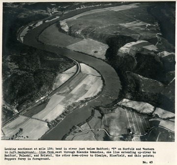
- 'Looking southeast at mile 138; bend in river just below Radford; 'Y' on Norfolk and Western in left background; line from east through Roanoke branches, one line extending up-river to Padford, Pulaski, and Bristol, the other down-river to Glenlyn, Bluefield, and Ohio points; Peppers ferry in foreground.'

- IDNO:
- 026339
- Title:
- New River Near Radford, Va.
- Date:
- 1932
- Description:
- 'Looking east northeast along second big bend of river below Radford. Virginian Railway reaches river from Roanoke and east near upper right-hand corner and follows down east bank of river; Norfolk and Western has crossed to west side and is about under plane.'

- IDNO:
- 026340
- Title:
- New River Near Churchwood, Va.
- Date:
- 1932
- Description:
- 'Looking south at mile 127; Norfolk and Western at right; Virginian Railway at left; Churchwood, Virginia, a coal mining town, near right foreground.'
- IDNO:
- 026341
- Title:
- New River Near Walker Mountain, Va.
- Date:
- 1932
- Description:
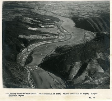
- 'Looking south at mile 123.4; Gap mountain at left; Walker mountain at right; Cloyds mountain beyond.'
- IDNO:
- 026342
- Title:
- New River Near Eggleston, Virginia
- Date:
- 1932
- Description:
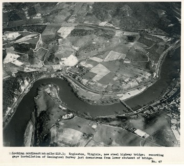
- 'Looking southeast at mile 1191; Eggleston, Virginia, new steel highway bridge; recording gage installation of Geological Survey just downstream from lower abutment of bridge.'

- IDNO:
- 026343
- Title:
- New River Near Pembroke, Virginia
- Date:
- 1932
- Description:
- 'Looking north northeast at mile 116.3 showing bend in river about half way between Eggleston and Pembroke. Foot of Doe Mountain in background.'

- IDNO:
- 026344
- Title:
- New River Near Eggleston, Virginia
- Date:
- 1932
- Description:
- 'Looking nearly east at mile 113.3 River visible almost to mile 121 just above Eggleston; Pembroke just off left edge of picture; limestone quarry in foreground.'
- IDNO:
- 026345
- Title:
- New River Near Pembroke, Virginia
- Date:
- 1932
- Description:
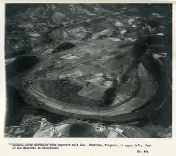
- 'Looking north northeast from opposite mile 116. Pembroke, Virginia in upper left; foot of Doe Mountain in background.'

- IDNO:
- 026346
- Title:
- New River Near Klotz, Virginia
- Date:
- 1932
- Description:
- 'Looking southeast at mile 110.3. Limestone quarry and cement mill in lower left; Klotz, Virginia, just above; State Highway no. 23 crosses bridge at Ripplemead near upper right; wet-weather ponds in sinks in Limestone near right edge.'

- IDNO:
- 026347
- Title:
- New River Near Pearisburg, Virginia
- Date:
- 1932
- Description:
- 'Looking northeast at mile 105.6. Pearisburg, Virginia, below and to right of picture; Norfolk and Western to right; Virginian Railway to left of river as in pictures 45 to 55; base of a spur of Peters Mountain in background.'
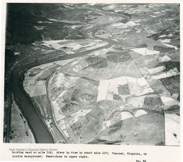
- IDNO:
- 026348
- Title:
- New River Near Wenonah, Virginia
- Date:
- 1932
- Description:
- 'Looking east at mile 102; river is view to about mile 107; Wenonah, Virginia, in middle background; Pearisburg in upper right.'


