Search Results

- IDNO:
- 000212
- Title:
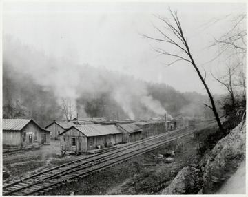
- Lumber Yard at Portes Creek
- Date:
- undated
- Description:
- Wooden buildings next to train tracks.

- IDNO:
- 000801
- Title:
- South Side of Charleston, W. Va. During the Civil War
- Date:
- 1863
- Description:
- Copy of painting by A.M. Doddridge, 1863- Army camp just below Chesapeake and Ohio Depot site near mouth of Ferry Branch on the Kanawha river. Fort Scammon Hill in the distance. President Hayes and McKinley were stationed in camp.

- IDNO:
- 000802
- Title:
- South Side of Charleston, W. Va. During the Civil War
- Date:
- 1863
- Description:
- Copy of painting by A.M. Doddridge, 1863- Army camp just below C. and O. depot site near mouth of Ferry Branch. Fort Scammon hill in the distance.

- IDNO:
- 001266
- Title:
- Junction Where Battle Between Averell and Patton Took Place
- Date:
- 1912
- Description:
- Junction of the Anthony's Creek Road and the James River and Kanawha Turnpike 'now route 60' where Averell's force met Patton's brigade in a head on collision. This was the scene of the fiercest fighting; the road in the center was filled with the dead and wounded. Photo taken about 1912 is from Mac Corkle's 'White Sulphur Springs. See West Virginia Collection Pamphlet 6610 and Boyd Stutler's 'West Virginia in the Civil War.'

- IDNO:
- 001429
- Title:
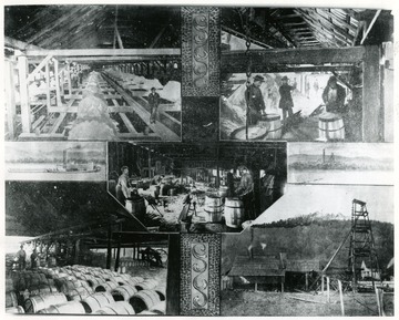
- Collage Images of the Salt Industry
- Date:
- undated
- Description:
- These pictures made before 1898 'probably at same time as Thompson made picture of entire plant'--also shown in this collection. Picture in upper left corner shows salt piled on drain boards after being lifted by hand from the crystalizing vats. Right upper picture shows salt being packed in barrels for shipment. Middle scene is in cooper shop. 'All salt at that time was shipped in barrels.' Lower left scene shows barrels of salt on platform ready to lower down incline to load on barges. Until the New York Central Railroad 'formerly the K&M' was built, all salt was shipped by barge or taken across Kanawha River and loaded on C&O Railroad at South Malden.

- IDNO:
- 001443
- Title:
- Kanawha Valley Salt Works
- Date:
- undated
- Description:
- A brine storage reservoir with a building on the rightside.

- IDNO:
- 001446
- Title:
- Drawing of Salt Works in Kanawha Valley
- Date:
- unated
- Description:
- Early drawing or engraving of the salt works in the Kanawha Valley.

- IDNO:
- 001449
- Title:
- Dickinson Salt Works as Seen from the Opposite Bank of the Kanawha River
- Date:
- ca. 1910
- Description:
- View of Dickinson Salt Works from opposite bank of Kanawha River. Made about 1910. This is the only picture in existance showing salt loaded on barge for ferrying across river where it was loaded on C&O Railroad. The New York Central Railroad had served the plant for years before this picture was taken, but due to higher freight rates by the NYC, it was still possible to ship by C&O to some points at a saving.

- IDNO:
- 001466
- Title:
- Grainer at Salt Works in Kanawha Valley
- Date:
- undated

- IDNO:
- 001478
- Title:
- Evaporating Sheds, Salt Manufacturing in Kanawha Valley
- Date:
- undated
- Description:
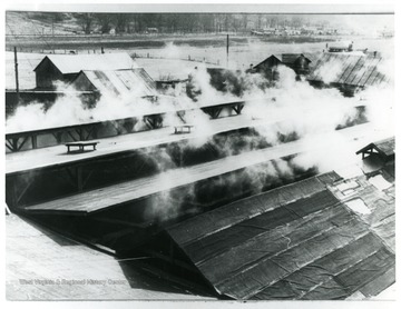
- Factory buildings with a smokestack to the right.

- IDNO:
- 001482
- Title:
- Evaporating Sheds, Part of Salt Manufacturing in Kanawha Valley
- Date:
- undated
- Description:
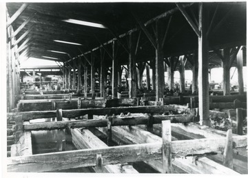
- Salt works evaporating sheds.

- IDNO:
- 001707
- Title:
- Bridge Under Construction in South Charleston
- Date:
- ca. 1908
- Description:
- Cut No. 1, This is a photograph of the immense combination bridge across the Kanawha River in South Charleston, now in process of Construction. This bridge is made to accomodate both the steam and trolley traffic and also foot-passengers. The illustration here given, shows the Concrete Piers which are nearly 20 feet thick and 90 feet high. It also shows the wooden superstructure necessary in the process of erecting the middle span of the bridge.


